On the 26 November 2022, the Royal Research Ship (RRS) Discovery arrived in James Bay, St Helena. The vessel had journeyed over 4000 miles from the UK, bringing an excellent team of scientists and technical crew specialised in deep-sea and pelagic ecology, fisheries acoustics and hydrology. The ship itself was equipped with a huge variety of tools to survey and explore the ocean.
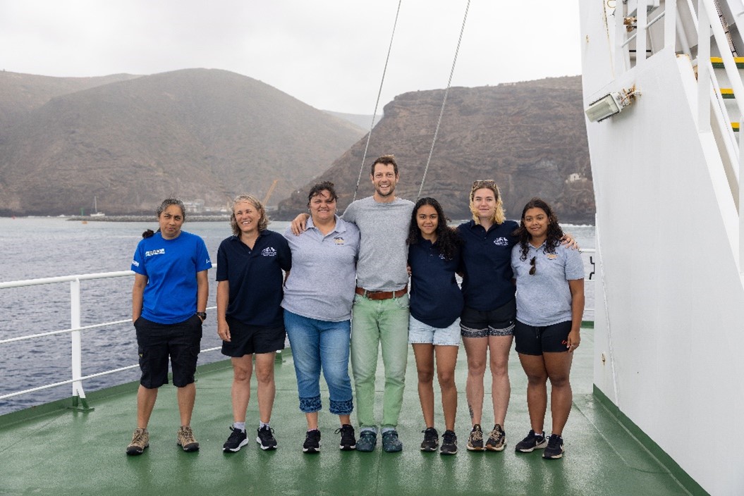
Myself along side four of my colleagues from St Helena Government’s Marine and Fisheries Conservation section, and two members of the St Helena National Trust’s Marine Team, would be joining the expedition for eight days. The expedition was delivered by the UK Government’s Blue Belt Programme, the international marine conservation scheme in the overseas territories.
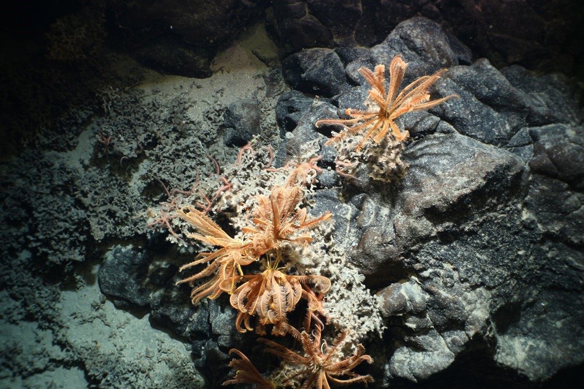
The expedition had just finished its first leg, visiting our sister Island, Ascension, 800 miles northwest of St Helena. They spent nine days exploring Ascension’s Marine Protected Area (MPA). They found vast fields of ancient glass sponges, bright orange black coral and a fantastic variety of deep-sea fish from Viperfish and fangtooths to a sixgill bluntnose shark.
When the vessel finally arrived in James Bay, we were all itching to get on board and see what we could discover in our MPA. Our primary objectives for the St Helena leg of the expedition were:
- Water quality sampling
- Data collection on marine habitats and species to inform future management
- Biomass assessments of key fish species, such as those important to local fisheries
- Mapping the seafloor of previously unexplored deep-sea habitats
- Receiving training and learning opportunities to help build on-island capacity for sustainably managing our MPA
All of the data that has been collected from the Discovery voyage, will result in scientific outputs and analysis that will actively support St Helena in protecting and managing its 200 nautical mile MPA.
Why me?
You might be asking yourself, “How did a teenager with little to no experience end up on the Discovery 159 expedition?”. In June 2022, I started a one-year apprenticeship with the St Helena Governments Marine and Fisheries Conservation Section, which was funded by the Blue Belt Programme, and has allowed me to learn a huge amount about what the Section does and how it manages the St Helena marine environment. In particular, I mainly worked with data collection and analysis. Shortly after accepting the role, I was also offered a place on board the RRS Discovery, where I could find out more about the scientific fieldwork that is needed to effectively manage and protect a vast MPA like St Helena’s. Over the moon with excitement, I said “yes!”, and soon after we set sail from James Bay.
My time on the Discovery
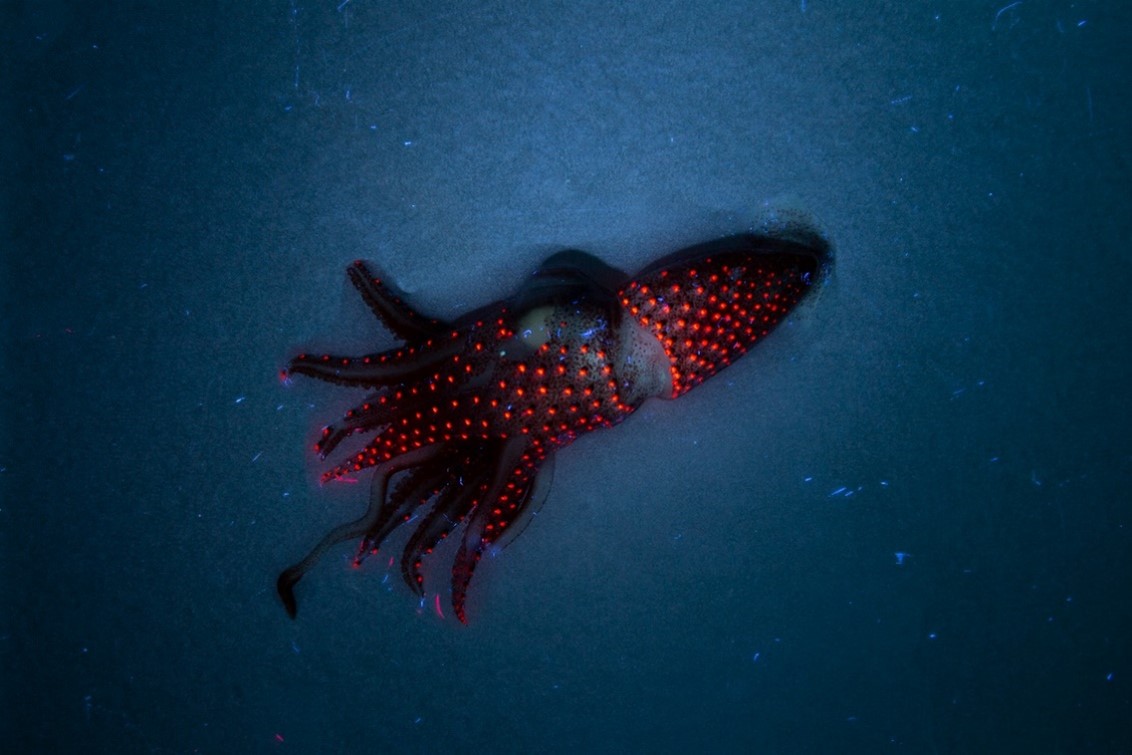
Whilst onboard the Discovery, I watched and learned from the scientists around me, assisting where I could. One of my favourite jobs was sorting and cataloguing the samples collected using the rectangular mid-water trawl (RMT), from starting depths of 1000m until the surface. We sorted these creatures into groups in an eight-degree cold room. Many of the deep-sea fish had large jaws, with jagged teeth, many were translucent or black, but most extraordinary was the discovery of the jewel squid (which we would later name the Disco Squid) and the possible discovery of a new species of angler fish.
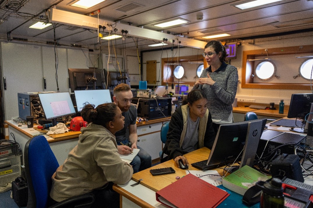
Another of my responsibilities whilst onboard included filtering water samples collected in niskin bottles. These bottles were attached to a CTD, a machine which measures conductivity, temperature and depth, creating a profile in the water column. I filtered these samples to assess the water quality, checking for microplastics and chlorophyll levels to determine different amounts of carbon and nitrogen in the food chain.
The team and I also had the opportunity to work with a member of Blue Abacus on the BRUVS (Baited Remote Underwater Video System) project. BRUVS are a frame with mounted GoPros which records underwater footage. We then reviewed the footage recording any species’ presence and abundance. Unfortunately, for St Helena we did not see much during our BRUVS deployment (except for a juvenile blue shark at one of the seamounts), however, during the Ascension leg of the expedition, a huge school of Galapagos sharks were recorded over Grattan seamount.
As well as all of this, the Discovery also worked alongside local fishers and the team were able to carry out bait fish sampling for the assessment of bait fish biomass, which will help us better understand the stocks of bait fish and therefore allow management of future stocks.
Additionally, I was also able to sit down with the two hydrographers on board, who were surveying and mapping the seafloor that the Discovery was passing over. Much of the seafloor in the offshore areas of both Ascension and St Helena have not been mapped in detail, and therefore this expedition was a chance to grow our knowledge of the seabed habitats and ecosystems that may be present. Working with the hydrographers, I was able to learn the basics of the process they use to clean noise from the bathymetry data they collect, therefore giving an accurate representation of the topography of the seafloor.
Finding & naming a new seamount
During the Ascension leg of the expedition, we were excited to hear that the team had uncovered a new seamount (an underwater mountain, on the north-west edge of their MPA, which previously was completely unknown). The now named ‘Burns’ seamount is around 80km2 in size, and has a highest point of 1200m above the seafloor.
Once the Discovery had finished work on Ascension, the vessel made its way to St Helena. On the journey, the scientists did have a hunch that there could also be an unmapped seamount in the St Helena MPA. As the ship passed over the coordinates 13046’57.865’S, 007030’35.339’W, the team mapping the seafloor saw a seamount almost the size of St Helena island itself emerging on their screens!
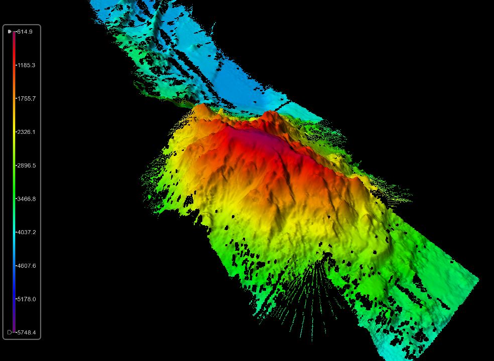
Earlier this year, a competition took place, to find a name for the newly discovered seamount. Local resident Sharon Wade’s entry was chosen from a total of 24 submissions by a small judging panel. The winning name of “Young Seamount” was submitted to HE Governor Nigel Phillips CBE, who approved the proposed name to be sent to the International Hydrographic Office for their consideration and approval. The name remembers the first St Helenian Captain of the Island service ship the RMS St Helena, Captain Rodney Young. It is a very fitting name for the seamount, given the years this captain spent navigating the sea, perhaps even coming close to the seamount without even knowing.
Leave a comment